Satellite navigation systems have come to affect countless aspects of our daily lives, from directing our holiday aeroplanes to enabling us to drive round an unfamiliar city without any map other than the one on our mobile phone. Most new cars sold today have an inbuilt Sat Nav and you can buy trackers relatively cheaply to enable you to track the whereabouts of your children and pets.
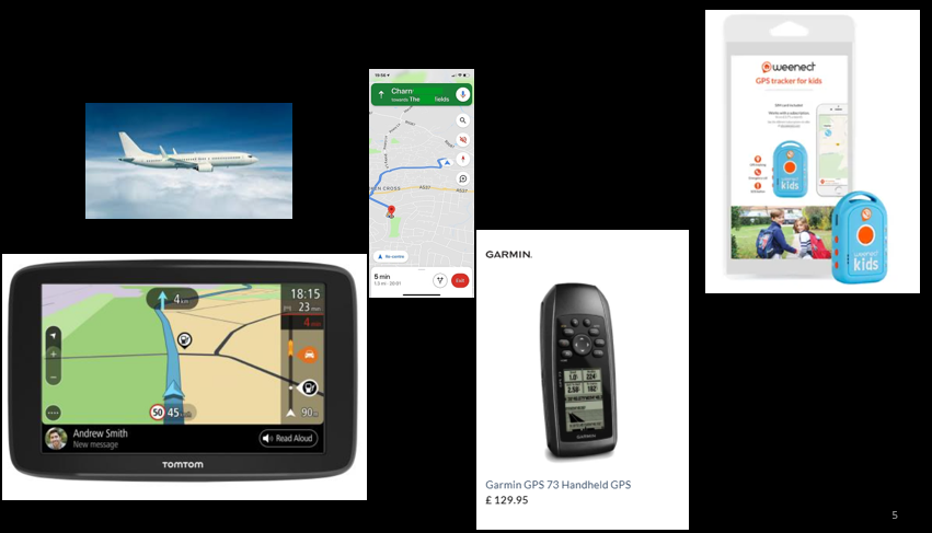
Some of the many Sat Nav Devices
I for one am heavily reliant on this technology to find my way from A to B. Although I enjoy using paper maps, they have the major limitation that they don’t tell you your current location!

Nearly half the world’s population has access to a smartphone which will normally have a Sat Nav chip.
GPS the first Sat Nav system
Although the term GPS (Global Positioning System) is sometimes used to mean Sat Nav, GPS is only one of the four global satellite navigation systems in use today. The others being GLONASS (Russia), Galileo (the EU) and BeiDou (China). GPS was the first Sat Nav system and the first to be made available for general civilian use.
The first GPS satellite was launched back in 1978 and by 1993 there were 24 GPS satellites in place giving complete coverage of the Earth’s surface. However, the system was primarily intended for use by the US military and its allies and it included a feature called Selective Availability (SA) that added intentional, time varying errors of around 100 meters to the publicly available navigation signals.
These errors were generated by an algorithm which used a classified key available only to authorized users (the U.S. military, its allies and a few other users) with a special “military GPS receiver”. Mere possession of a GPS receiver wasn’t enough you also needed to have the key which was changed frequently.
All this changed in 1996 when President Clinton announced that Selective Availability would be switched off making the system fully available for civilian use by the year 2000.
I suspect that few people in the mid 1990’s anticipated that this would kick start a massive industry and that by 2021 almost half of the world’s population would have their own Sat Nav receiver on their smartphone.
Overview of how Sat Nav works
I’ll give the example of GPS here, but all Sat Nav systems work the same way.
GPS has a network of satellites in Middle Earth Orbit, roughly halfway between Low Earth Orbit satellites, such as the International Space Station, and the higher Geostationary orbits used by satellites which transmit TV signals.
Since 1978, there have been 76 launches in total but due to the limited lifespan of the satellites, there are actually 31 working satellites -the older satellites remain in orbit but have been retired from service. The satellites are in six separate orbits. Each at a height of 20 200 km above the Earth’s surface, but at different angles to the equator, as shown in the diagram below.
As each satellite moves in its orbit, it will appear to an observer on the Earth to rise, move slowly through the sky, and then set a few hours later. From a given location on the Earth there will be 7 or 8 visible at a given time but, as I’ll explain later, you only need to get a good signal from four satellites to get an accurate position.
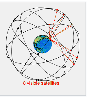
The satellites which are above the horizon are shown in red. The satellites which are below the horizon and thus cannot be seen are shown in black – Image from wikimedia commons
Each GPS satellite has a set of atomic clocks, accurate to a few billionths of a second per day. These clocks are kept in step with atomic clocks on the ground, so the clocks on the GPS satellites all show the same time. The satellites have a transmitter which sends a signal to Earth. The power of the signal is around 500 watts, which is roughly similar to the power radiated by the transmitter on a mobile phone mast. There are three parts to the signal:
· which satellite is sending it
· a very accurate time signal,
· the position of both itself and every other satellite.
When a GPS receiver receives the signal it compares the time it arrived with the time it was transmitted and can work out how long the signal has taken to travel. The distance to the satellite can therefore be worked out using the simple formula:
distance = time x speed.
The speed is the speed of light, since radio-waves and light are both forms of electromagnetic radiation. Therefore, if a GPS signal takes 0.1 seconds to reach us and, because the speed of light is 299,792.458 kilometres per second, its distance is:
0.1 sec x 299 792.458 km/sec = 29 979.2458 km
Measuring how long the signal takes to get to you from a single satellite only tells you the distance from that satellite, not your location. As I’ll show in the worked example, to get your position on the Earth you would need to know your distance from four satellites.
Example
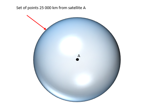
If we know that we are 25000 km from satellite A then our location must lie on the surface of the sphere shown below.
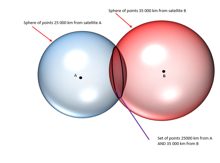
If we also know that we are 35000 km from satellite B then our location must be on the ring of points where the two spheres intersect
If we also know that we are 21 000 km from satellite C then our location must be where the three spheres intersect. So it must be at either location x or location y.
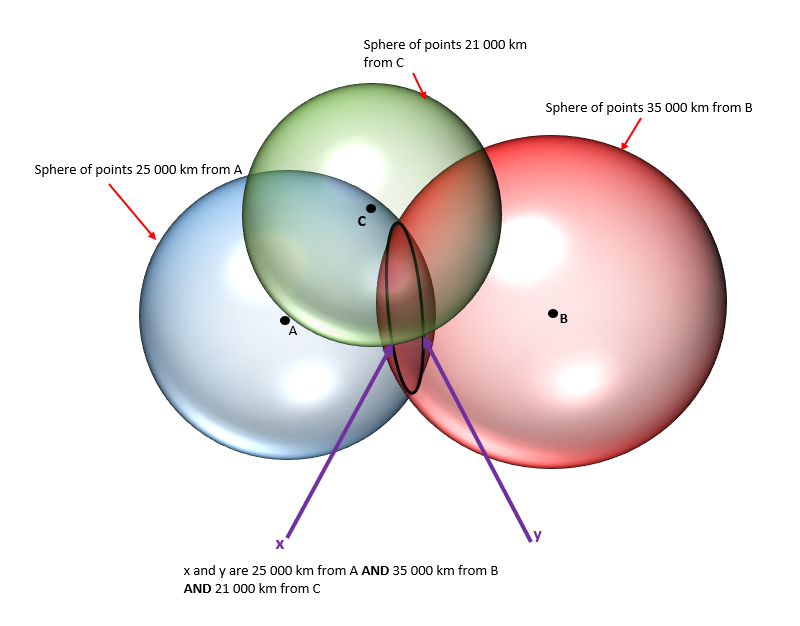
Although there are two possible locations (x and y) only one of these will be at a sensible location on or near the surface of the Earth.
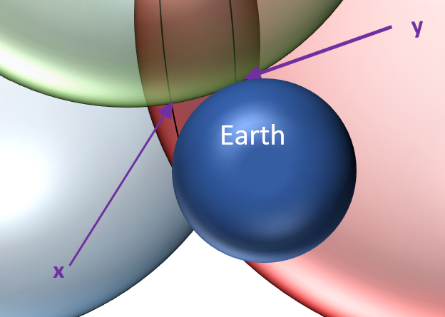
Because the GPS receiver does not have an accurate atomic clock it cannot know the current time as accurately as the GPS satellites. The clock on the GPS receiver will be fast or slow by a small fraction of a second. To get an accurate measure of the time taken for the signal to arrive, the clock on the GPS receiver must synchronise perfectly with the clocks on the GPS satellites. The way it gets around this is by using the time signal from a fourth satellite to work out the amount of time by the which the receiver is fast or slow. (The signal from the fourth satellite also confirms which of the possible locations (x and y) in the diagram above is correct)
—————————————————————————————————————————-
Relativistic Corrections
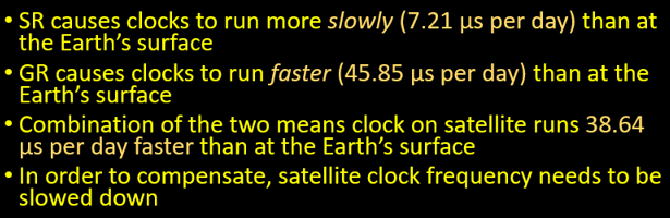
Because the satellites are in space orbiting the Earth at 14 000 km/h, their atomic clocks run at slightly different speeds compared to atomic clocks on the Earth’s surface. There are two separate effects which work in opposite directions.
- Einstein’s theory of special relativity predicts that moving clocks run slow and means that the so the atomic clocks on the satellites should run at a slower rate than identical stationary clocks.
- However, Einstein’s theory of general relativity tells us that clocks run more slowly in proximity to a massive object (in this case the Earth) so the atomic clocks on the satellites should run at a faster rate than identical clocks on the Earth’s surface.
Taken together, the two effects mean that time on a GPS satellite runs slightly faster than it does at the surface of the Earth at the incredibly small rate of just under 46 millionths of a second per day. Because of this GPS satellites’ atomic clocks need to be slowed down to keep them in step with atomic clocks on the surface of the Earth.
Limitations of Sat Nav
There are limitations to the accuracy of position provided by GPS (or indeed any Sat Nav system). One is that the speed of radio waves is not constant. Conditions in a region of the upper atmosphere, known as the ionosphere, can cause them to slow down slightly. This makes the time taken for the signal to arrive at the receiver slightly longer, implying that a satellite is further away than it actually is. Another factor is that large objects such as trees between the receiver and the GPS satellite may weaken the signal or even block it altogether.

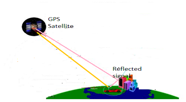
An additional false signal can also be generated when a GPS signal is reflected off tall buildings. This effect, which is known as a multi-path error, is shown in the diagram below. The receiver receives two signals from the same satellite: a direct signal (the yellow line) and a reflected signal (the pink line). The two signals have travelled different distances, so the GPS receiver calculates two different distances to the same satellite. This can result in an incorrect distance if the wrong signal is chosen by the receiver. Alternatively, the two signals can interfere and cancel each other out so no signal is received.
Errors could also be caused by slight inaccuracies in the atomic clocks on the satellites or by the satellite making an error when calculating its own exact position. Nevertheless, even taking all these factors into account, a GPS receiver should be able to work out its position to an accuracy of within 10 metres. This, however, only applies to locations outdoors and above ground, as the signal cannot travel through buildings with thick walls.

Improving Sat Nav Accuracy
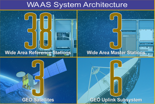
For non-civilian users, who need to know their position to greater precision Sat Nav can be augmented in a number of ways to provide better accuracy. For example, satellites transmit on multiple frequencies and more than one of these frequencies can be used. This is too large a topic to fit in this post, but if you want to know about one system, WAAS used by the US Federal Aviation Authority, please click on the link belowhttps://www.faa.gov/about/office_org/headquarters_offices/ato/service_units/techops/navservices/gnss/waas/howitworks/

Well I learned something today! I didn’t realize there were alternative systems to GPS. I knew other countries had launched their own navigational satellites, but I just assumed everything was integrated into one system. I didn’t realize we had four separate systems operating at once.
LikeLike
Yes think the reasons that the Russia, China and the EU have their own sat nav systems is that they don’t want to to be dependent of other nations for such a key piece of infrastructure !!
LikeLiked by 1 person
That makes sense.
LikeLike
All of us average Joes benefit enormously from the few very smart people!
LikeLiked by 1 person
Very true 🙂
LikeLike